NOTE: Please leave dogs at home, they are not allowed on the majority of trails here. Review the full list of policies here before visiting.
Trail Network
There are nearly 11 miles of trails in the network at this time. The trails are a mixture of novice, intermediate, and advanced levels. All trails but especially the advanced ones tend to have challenges and features - sometimes with a B line, sometimes not. The network provides for solid rides of 6-12 miles, depending on difficulty level, all staying within the local trail system. With some creativity, it is also possible to connect to other public lands and other trail systems for loops of 15 or more miles.
Get the color PDF map here or print out the two-page pocket guide with a map, directions, and list of trails. There are three areas of trails, which are all connected: Upper Turnpike Trails (west side of Route 47), Lower Turnpike Trails (east side of Route 47), and the Fisher Hill Town Forest (also on the east side of Route 47).
Parking
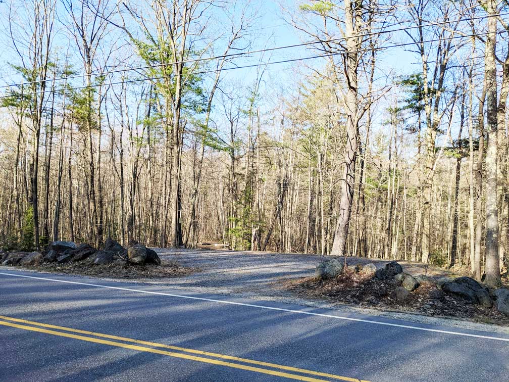
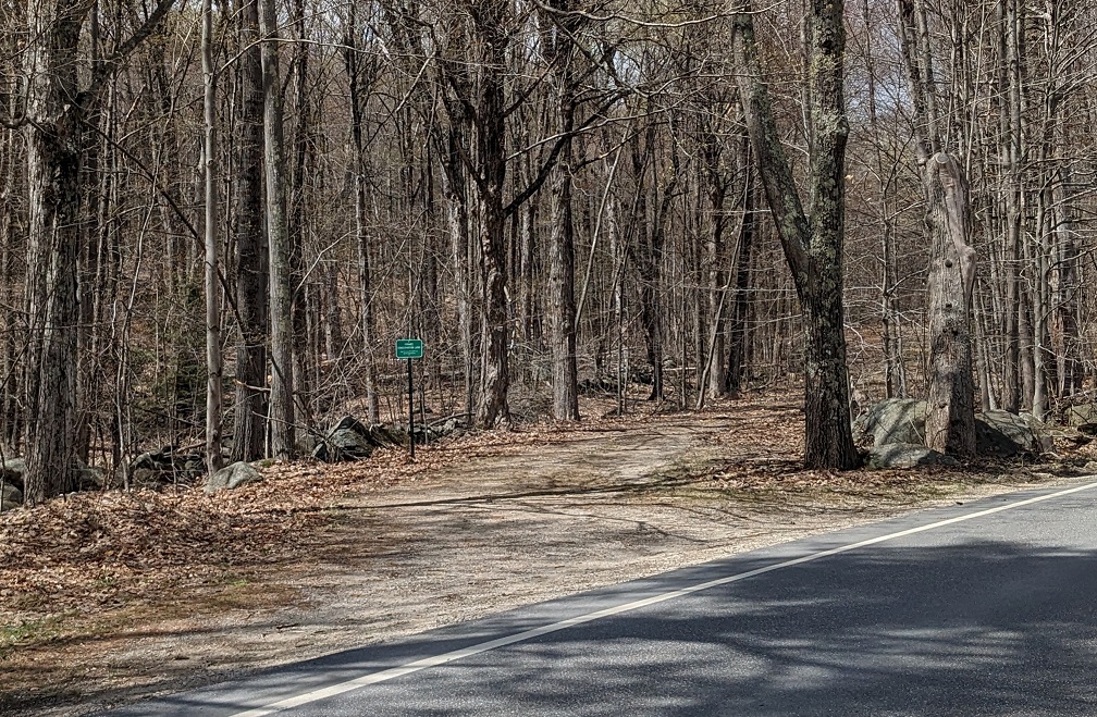
There are two parking locations: First is a small lot at the Fisher Hill Town Forest on Route 47 which is Town of Francestown property. This lot has room for 3-4 cars and is probably the best parking choice for most visitors with 1 or 2 cars (see upper picture). There is a brown sign on a tree which says simply "Town Forest." Alternatively, there is an old road across the street which leads to an open area after a couple hundred yards with room for 6 or 7 cars, located on private property but made available for parking (see lower picture). This is the Upper Turnpike Trails area. This open area is adjacent to a large historical boulder called "Signature Rock" which can be seen from the road up behind some old foundations. There are a few exposed rocks on the old road so be careful with a low clearance vehicle. The trail network can be accessed directly from either parking location. Note that there is a storage container/utility building at Lower Turnpike Trails - this is NOT public parking but remains private to the landowner. However, a trail to Lower Turnpike Trails goes across Route 47 and through this area so you are free to ride through.
Trail Descriptions
Trails are color-coded on the map (and often on the signs) by general technical difficutly. All trails, regardles of color, may involve sections with challenging climbs or the occasional more difficult spot, such as a stone wall crossing. Any trail may also have one or more optional, more difficult challenges. However green trails overall have the fewest difficult technical sections or features, whereas blue trails tend to have multiple challenging sections or features which may be unavoidable, and dark blue and black trails tend to have intense climbing challenges and/or difficult features which cannot be avoided. Overall ratings across the network may be more difficult than other trail systems due to the overall hilly, rocky terrain found in this area.
Upper Turnpike Trails
Little Deuce Coupe: This is a fairly easy and somewhat short access trail that connects the signature rock parking area and Route 47 to the upper trails.
Runnin Down a Dream: Very asthetic cross-over trail that brings one to the main junction in the center of Upper Turnpike Trails. This intermediate trail has some very tight switchbacks which can be a challenge in either direction, but otherwise there are few difficulties. The west end of this trail comes out on the old turnpike road at the bottom of an old recreational trail. Climb up this old recreational trail to access two more difficult trails, Bumpy Ride and My Corona. The trail is a bit over 1/3 of a mile long.
My Corona: This advanced but fun trail is loaded with features and challenges. Best flow is downhill - enter on the left at the top of a short steep climb on the old recreational trail. Enjoy the famous "picnic table" roll-over! Trail ends on the old turnpike road just uphill from the Little Deuce Coupe/Runnin Down A Dream intersection. This trail is 3/4 of a mile long.
Bumpy Ride: Another advanced trail with some very challenging rock features but a very unique personality if you like that stuff. There is some debate about which direction rides better. To take the more downhill flow, enter on the right near the top of the climb on the old recreational trail. To go uphill, and come out conveniently near the entrace to My Corona, enter from the far end of Route 66 or Little Red Corvette by crossing over the stone wall heading uphill. Both directions are quite challenging with their own trouble spots. This trail is 4/10 of a mile long.
Little Red Corvette: This short, flowy and fairly easy trail connects the end of Bumpy Ride on the old turnpike road back to the junction at the center of Upper Turnpike Trails, at the base of the recreational trail. There are a couple optional features including a large boulder roll-over. This trail is about 1/3 of a mile long.
Red Barchetta: A short variation trail to Little Red Corvette, which provides for a fun and flowy loop.
Route 66: This intermediate trail is the longest trail on Upper Turnpike Trails at approx. 1.1 miles, and crosses almost all of the property east/west. It contains a mixture of terrain; most of the trail rides fairly smoothly but several short but more difficult sections bring the grade to solid intermediate. This is a good option to make a long loop by combining with Bumpy Ride or Little Red Corvette.
Sidecar: This relatively short and easy trail makes a number of useful connections amongst other trails in the area and provides a convient bail-out to get back to the parking area if needed. The trail itself is about 3/10 of a mile long.
Old Turnpike Trail: A flat and easy trail that follows an intact section of the original 2nd NH Turnpike. Useful for connecting various loops particularly that involve My Corona and Bumpy Ride.
Lower Turnpike Trails
Driver's Seat: This fun and easy trail links the town forest connector and other trails at Lower Turnpike Trails. It can be reached by biking past the storage container from Route 47 and taking a quick right after the open area, or it can also be accessed via a short connector trail from the open "log landing" at Fisher Hill Town Forest. The trail follows a stone wall passing a couple of large boulders, passes by the entrance to Road To Nowhere, then crosses a stone wall where it takes a wandering line to eventually connect with Chasing Cars. To reach 92 Subaru at that point, turn right at the end of the trail. There are a few optional features with B lines for all. This trail is just under a 1/2 mile in length.
Chasing Cars: Instead of turning right onto Driver's Seat after passing the storage container, you can continue straight along an old logging road which takes a left hand turn to eventually enter an open area after a few hundred yards. Across the open area the trail enters the woods and follows an old recreational trail, going past the end of Driver's Seat and continuing on to access 92 Subaru and beyond, all the way down to Old County Road North where there is a bridge and a small waterfall. Along the way the trail enters property owned by the Francestown Land Trust. This trail is pretty easy the whole way but it is long downhill to the waterfall which is just under a mile from the beginning point at the storage container.
92 Subaru: This intermediate loop trail is a fan favorite which is accessed from Chasing Cars (entrance and exit are from this trail) and it winds around some very nice areas of the forest with a handful of modest challenges along the way. At the furthest entrance (north) there is a crushed Subaru very near the entrance. It rides well both directions with a couple challenges either way that will keep up the excitement. If you continue downhill beyond the crushed Subaru you are still on Chasing Cars until you cross a bridge and it turns into the "St. Jean Trail" which will eventually come out on Old County Road North where there is a wooden bridge and waterwall. The trail is about 2/3 of a mile long.
Road To Nowhere: This is the longest trail in the network at 1.3 miles. It is a long loop through varied terrain and beautiful rocky forest areas with plenty of flowy terrain and a lot of climbing in both directions. New! There is a now a bypass to allow riding a shorter and easier loop of approximates 0.7 miles on just the upper part of the trail. The lower section is much more difficult primarily due to sustained climbing and some technical rocky sections which can't be avoided. The lower section includes the fun but optional "humpback" rock slab which rides best clockwise.
Fisher Hill Town Forest
For further information about the Fisher Hill Town Forest, please see the Francestown web site.
Access Road: From the Fisher Hill Town Forest parking area go around the split rail fence along an access road to reach an open "log landing" and the start of the trails. The trail called Putnam Loop begins and ends at this log landing. Also from this point, a connector trail on the left can be used to reach Lower Turnpike Trails.
Putnam Loop: This is a rocky but overall easier trail that loops around the town forest on terrain that never gets very steep. There is one bridge crossing with an optional high bridge that is much easier when riding the loop in the counter-clockwise direction and fairly challenging in the clockwise direction. At two points along this trail there are junctions with the longer and much harder Perimeter Trail, as well as the Fisher Hill Trail. To keep the easiest terrain, stay on the Putnam Loop which is the inner loop. The loop is around 3/4 of a mile overall.
Perimeter Trail: This is an advanced trail with a number of rocky, difficult sections in either direction. Most people feel it rides best in the clockwise direction. The beginning and end of the trail are accessed from the Putnam Loop trail and there are signs. The technical, rocky sections do not have a B lines for the most part so be prepared and be careful. Don't miss the big rock/ramp roll-over about half way around when riding clockwise. This trail is about 3/4 of a mile long, from the junctions with the Putnam Loop.
Fisher Hill Trail: The newest trail in the town forest was added in December 2023. This is a wonderful trail up and around the five small summits of Fisher Hill with views depending on the season. Don't miss checking out the old sap collection bucket, which was found when the trail was being constructed. The trail involves some fairly steep climbing when following the trail from south to north, but overall it is not a technically difficult trail. For the most downhill, flowy terrain, take the trail from north to south. The beginning and end of the trail are accessed from the Putnam Loop trail and there are signs. This trail is about 3/4 of a mile long, from the junctions with the Putnam Loop.
Help Out
If you want to keep up to date on these trails or participate and contribute to trail work, please join the Turpike Trails Google Group.